
UNESCO Global Geoparks in Japan
As of 23 April 2026, there are 241 UNESCO Global Geoparks in 51 countries.
11 of them are in Japan.
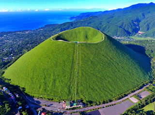
Mt. Apoi UNESCO Global Geopark
Global Geopark Network Designated Year: 2015
UNESCO Global Geopark Designated Year: 2015
|
Focusing on the theme “A story of treasures from deep within the Earth that connect the land and people together,” Mt Apoi’s geo-story began approximately 13 million years ago when two continental plates collided to create the Hidaka Mountains. During this collision a part of the upper mantle rose to the surface, depositing the Horoman Peridotite, and forming Mt. Apoi. This rare peridotite attracts attention from around the world as it contains precious information from the Earth’s mantle. |
 |
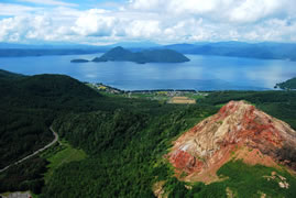
Toya-Usu UNESCO Global Geopark
Global Geopark Network Designated Year: 2009
UNESCO Global Geopark Designated Year: 2015
|
Since 1663, Mt. Usu has erupted 9 times. This volcano is considered unique throughout the world due to its frequent deposition of lava domes, which can be viewed up close and personal. There are also remains of the Jomon and Ainu peoples who lived in this area from thousands of years ago, and enjoyed the natural bounty that frequent volcanic activity brings. Since the aboriginal Jomon-Ainu people first inhabited the area, their principle philosophy has been “living together with the ever-changing Mother Earth”. |
 |
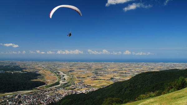
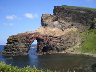
Izu Peninsula UNESCO Global Geopark
UNESCO Global Geopark Designated Year: 2018
|
UNESCO Global Geopark Designated Year: 2018 The greater Izu Peninsula is a unique place in the world where two active volcanic arcs meet, and both the collision and the various phenomena that arise from it are still in progress today. The Izu Peninsula first began forming about 20 million years ago, as a small volcano on the sea floor, at the time located about 800 km to the south. The Philippine Sea Plate, which the volcano was located on, drifted north and collided with the mainland about 1 million years ago, creating the base for the current Izu Peninsula. After that, terrestrial volcanoes continued to erupt and active crustal deformations developed the current topography of the Peninsula. As a result, the Izu Peninsula is a land in motion, with rich biodiversity and cultural diversity. |
 |
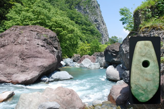
Itoigawa UNESCO Global Geopark
Global Geopark Network Designated Year: 2009
UNESCO Global Geopark Designated Year: 2015
|
The Japanese Islands are split down the center by a massive fault called the Itoigawa-Shizuoka Tectonic Line. At Itoigawa Geopark, you can learn how this fault gave rise to the massive Japanese Alps and the role it played in the formation of the Japanese Island Arc. Also discover how it produced Itoigawa's beautiful gemstone jade, fostering the world's oldest jadeworking culture. |
 |
Hakusan Tedorigawa UNESCO Global Geopark
UNESCO Global Geopark Designated Year: 2023
|
Hakusan Tedorigawa UNESCO Global Geopark is an important area for its internationally important fossil site from the early Cretaceous, which gives insight into the paleoenvironment of East Asia, as well as the evolution of life. The area around Mt. Hakusan is the world's closest high snowfall area to the equator, and is an area undergoing a high speed of uplift. The changes from the upper to lower regions of the short Tedori River symbolize the rapid and intense topographical development of Japan, and showcase the distinct features of the snowy natural environment found in the Japanese Archipelago. The region is a place where the strong connections between people, the blessings of nature, and the formation of the land can be deeply felt. |
 |
San’in Kaigan UNESCO Global Geopark
Global Geopark Network Designated Year: 2010
UNESCO Global Geopark Designated Year: 2015
|
Stretching across Kyoto Prefecture (Kyotango City), Hyogo Prefecture (Toyooka City, Kami Town, and Shin’onsen Town) and Tottori Prefecture (Iwami Town and Tottori City), the San’in Kaigan Geopark is a Geopark that measures about 120 km east-west and has an area of 2,458.44㎢. Based mainly in the area covered by the San’in Kaigan National Park, the San’in Kaigan Geopark boasts unique landscapes with a variety of geological features. These various features cover geological formations from 25 million years ago during the formation of the Sea of Japan until recent times. |
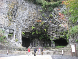 |
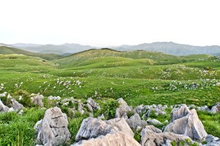
Miné-Akiyoshidai Karst Plateau UNESCO Global Geopark
UNESCO Global Geopark Designated Year: 2026
Miné-Akiyoshidai Karst Plateau Geopark is located in Mine City, and focuses on the legacies of white limestone, black coal, and red copper. The first highlight is the limestone of Akiyoshidai karst plateau, which was formed approximately 300 million years ago and preserves an 80-million-year record of marine environments. Underneath lies Akiyoshido Cave, a limestone cave with a labyrinthine groundwater system. The second highlight is Triassic anthracite which originated from plants approximately 200 million years ago, from which valuable insect and plant fossils have been discovered, as well as a history of coal mining. The third highlight is copper that was formed approximately 100 million years ago through the reaction of limestone with hydrothermal water. Copper from the oldest government-operated copper mine in Japan was used to build the Great Buddha of Nara. |
 |
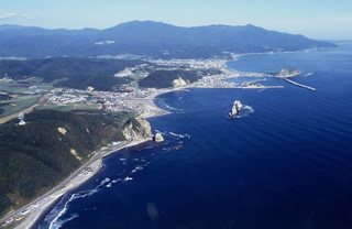
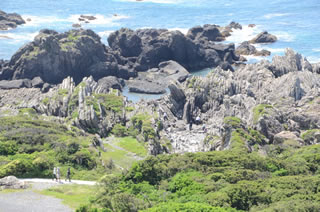
Muroto UNESCO Global Geopark
Global Geopark Network Designated Year: 2011
UNESCO Global Geopark Designated Year: 2015
|
Muroto UNESCO Global Geopark covers the entire administrative area of Muroto City. Here you can experience land formation processes, and feel the dynamic movement of Earth. Detailed research is being carried out on the geology of the Shimano Belt accretionary complex*, the first terrestrial complex to demonstrate plate tectonic theory, as well as on the Geopark’s beautiful marine terraces that formed through a combination of sea level changes and co-seismic uplifts. The Cape Muroto Sub-Tropical Vegetation and Coastal Vegetation Community, designated as a National Natural Monument, also contributes to the unique landscape of the Geopark. *An accretonary complex is an area where parts of oceanic crust accumulate on the edge of a continental plate. |
 |
Oki Islands UNESCO Global Geopark
Global Geopark Network Designated Year: 2013
UNESCO Global Geopark Designated Year: 2015
|
Oki Islands UNESCO Global Geopark is located on a small group of islands in the Sea of Japan. Here you can enjoy a story of connections between the scenery, geology, living things, and local culture and history, all originating from the unique geohistory of the islands. These small islands are a perfect place to observe rocks that record the formation processes of the Sea of Japan and the Japanese Archipelago, learn about the unique ecosystem created by climate changes in the Quaternary period, and explore a culture that is closely connected with the natural environment. |
 |
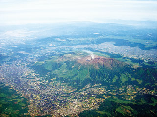
Aso UNESCO Global Geopark
Global Geopark Network Designated Year: 2014
UNESCO Global Geopark Designated Year: 2015
|
Aso Caldera, the symbol of Aso UNESCO Global Geopark is one of the largest calderas in the world. It was created over several hundred thousand years of volcanic activity. A super eruption occurred 90 thousand years ago, causing large pyroclastic flows and ash falls. The ash falls spread to cover nearly the entirety of Japan, and the pyroclastic flows covered the majority of Kyushu Island. You can visit the eruption center, the Aso Caldera, and feel the breath of the Earth, and the effects that the eruptions had to human society and the nature of the Earth. |
 |
Unzen Volcanic Area UNESCO Global Geopark
Global Geopark Network Designated Year: 2009
UNESCO Global Geopark Designated Year: 2015
|
The Geopark is located on the western edge of Japan, in the southern part of Nagasaki Prefecture in Kyushu, called the Shimabara Peninsula. The Shimabara Peninsula is made up of three administrative districts (Shimbara, Unzen and Minamishimabara) surrounded by the sea, with the Unzen Volcano in the center. The northwestern part of the Shimabara Peninsula consists of Mt. Unzen, the calm hills connected to it, and the plains along the coast. The eastern part is a sloping landscape with the base of the Unzen Volcano extending to the sea, and the southern part has a gentle topography. You can learn about the disasters caused by the eruption of the Unzen Volcano and the subsequent recovery, enjoy the blessings created by the volcano, and see the relationship between the various terrains and local people. |
- What is JGC
- UNESCO Global Geoparks in Japan
- Application and Designation Flow for Geoparks in Japan
- Links